The RTA Provides Free Maps!
These FREE PDF maps, or a gps device with RTA trail information, are essential when hiking any of the Rideau Trail network. As changes to the Rideau Trail network are made, they are incorporated into the maps and descriptions.
When planning a hike, be sure to consult the Trail Alerts page before heading out
Google Earth and GPS Devices
The RTA provides kmz files that can be imported into Google Earth, smartphone apps and GPS devices. Each file shows up as a separate layer in the host application and provides detailed information on the RTA trails and waypoints. Also provided are files with information on parking, water sources, Toilet facilities, and overnight accommodation options.
Uploading Files to Google Earth
A Waypoints file can be downloaded to show, in Google Earth, all the wayppoints along the Rideau Trail.
Google Earth Pro can be downloaded as an application on your computer or used within your web browser. Google Earth Pro is free for users with advanced feature needs such as saving projects. The video below is a tutorial for uploading files to the Google Earth web version.
Be prepared: In addition to GPS devices, mobile apps such as Gaia, AllTrails and Root & Branch are available. It is recommended that you download the PDFs to your phone via wifi to avoid data charges.
Measure Waypoint Distances
Experimental: Want to measure the distance between Rideau Trail Waypoints? A spreadsheet is available for download. (Updated Apr 2021)
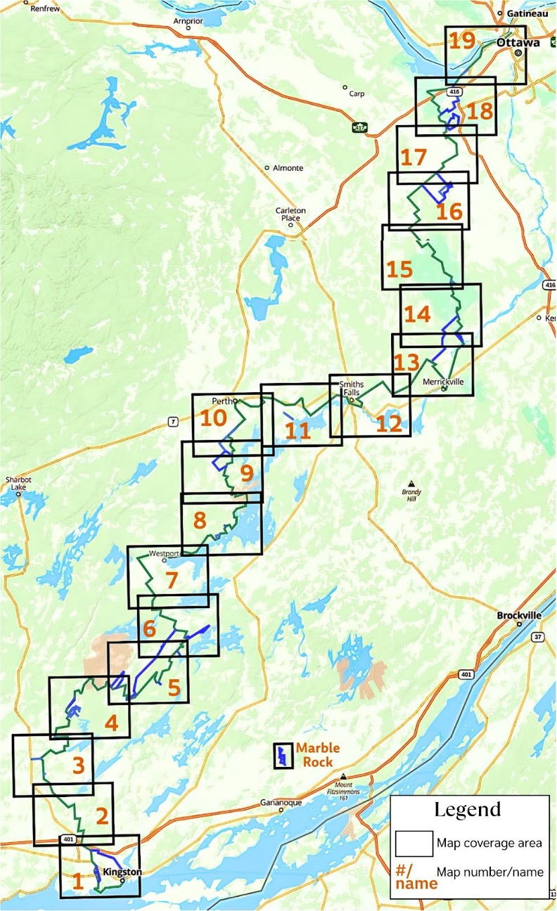
Maps
All maps are oriented with North facing at the top of the page.
Green lines: RTA main trail
Blue lines: RTA connectors/loop trails that are not part of the main trail
-
-
-
-
-
-
-
-
-
-
-
-
-
-
-
-
-
-
-
-
-
-
-
Maps Supplement – Trail Descriptions
In the linked file there are text based descriptions of the RTA main trail, organized by map number and based upon hiking South to North
Updated on:
Sectors
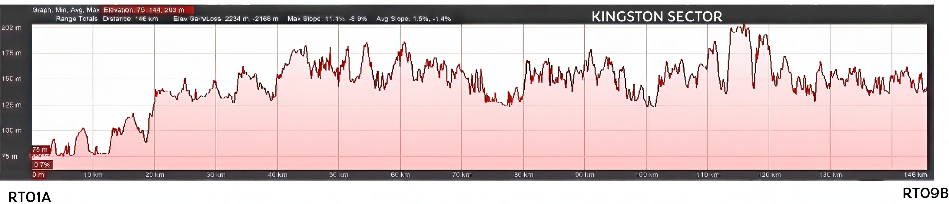
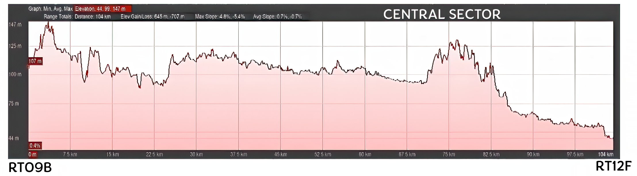
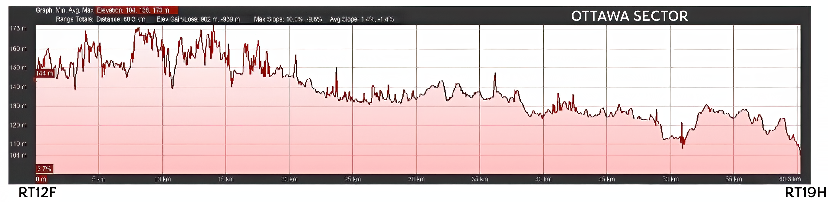
For marking and trail maintenance purposes, the area of the Rideau Trail network is divided into 3 sectors. South to North these are Kingston, Central and Ottawa.
The Kingston sector goes from downtown Kingston (Waypoint RT 01A) to Lally Homestead (Waypoint RT 09B); and encompasses maps 1-8 inclusive. The diagram below shows the elevation changes involved:
The Central sector goes from Lally Homestead (Waypoint RT 09B) to Waypoint RT 12F at the corner of Wood and Rosedale Roads; and encompasses maps 9 – 12 inclusive. The diagram below shows the elevation changes involved:
The Ottawa sector goes from RT 12F to where the Rideau River empties (via locks) into the Ottawa River (RT 19H); and encompasses maps 13-19 inclusive. The diagram below shows the elevation changes involved:
If you find these maps useful, you can support their maintenance by becoming a member of the Rideau Trail Association!